Some analysis I made for a seminar course I'm attending in the university.
-
Recent Posts
Recent Comments
Archives
Categories
Meta
Some analysis I made for a seminar course I'm attending in the university.
While driving through South-Iceland last Saturday, the stratovolcano, Hekla got my attention. What I noticed was was the snowless areas on the volcanic debris pile called Litla-Hekla. Why is this area without snow?
I went the other day the field in the quarry at Undirhlíðar where I plan to start my master thesis in couple of weeks from now. I had an unpublished stratigraphy map from my supervisor in the thesis but I must admit I had some difficulties. I did not see anything from the map in the quarry. The quarry I was in is a big one so I was walking there for perhaps one hour with no success at all. Not starting very well one could say.
 Any ways, luckily enough I also looked in to the other quarry, the smaller and there I did find everything. I did some photographic work with not so bad result and at least I can use the photos for further planning of the fieldwork that will start hopefully in beginning of May. What I will be doing is to take some drill cores for magnetic analysis.
There is a lot of pillow lava in those querries, as well as dykes, possible a sill or sheet like pillows, some tuff and even some sediment layers. The typical pillow lava is on the photo here on the right hand side.
 Sometimes someone takes my photographs without telling me, sometimes I'm mentioned as the owner of the photo and sometimes not. I came upon a photo from my Flickr page on another webpage today but this time I was rather proud. It appeared on the Icelandic science web, Vísindavefur and is on a page describing what is an erratic, or Grettistak if I use the Icelandic word for it. The authors on this science web are usually professors or other scientists of the Icelandic universities or institutes. The author that decided to use my photo is Sigurður Steinþórsson, retired mineralogy professor from the earth science department of the University of Iceland. I don't know him personally but in the university people usually tend to speak about him as a legend. So I must say he is welcome to use my photo and also it is made clear on my photo page for this photo it is allowed to use it if I'm mentioned as the owner of the photo!
I also like this photo quite a lot and used it for example in a firs year university paper I wrote about the icelandic glaciation history.
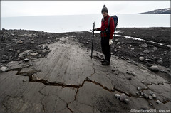
 From a glacier measurement tour with my brother to Hagafellsjökull Vestari last autumn - Hagafellsjökull is one of the outlet glaciers from the ice cap Langjökull. A smooth whaleback newly appearing from the retreating glacier. Note the fracture on top of it and imagine how the distal part (distal from the glacier) of the whaleback will most likely be eroded away in the next adwance of the glacier or in the next glacial period. After that we will most likely have very steep lee side of the whaleback and that would be called roche moutonnée.
This development of a whaleback into a roche moutonnée doesn't fit completely what has been written about the necessity of cavities and low pressure on the lee side of the bedrock. I can't see why the low pressure is needed to make the steep lee side end after the fracture has been made there.
 This whaleback is also remarkably similar to the famous Kirkjugólf (church floor) in Kirkjubæjarklaustur in Sout-East Iceland, south of Vatnajökull glacier. Here you can see a photo of that place from 2011 when I was there with other geology students in a study trip for first year students in general geology.
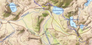
 From last summer (2013) hiking tour in Fjallabak in Iceland ("Behind the mountain") my group came where this nice outcrop is close to the mountain road Dómadalsleið and is south of the road in Dómadalsháls, location N64.02442 W19.15686. There are two very prominent double ash layers. Hekla was suspected but at least I was not sure and Hekla 3 and Hekla 4 was assumed possible.
 After some discussion it became clear it is from Hekla but not from Hekla 3 and Hekla 4 but layers referred to as Hekla X and Hekla Y and belove them should be the layer Hekla Z a thicker layer but not visible or present for some reason in this outcrop. Those layers are from rather small eruptions in Hekla dated in the period 1850 – 2800 BP 1. and looking very similar to those layers investigated by Meara (2012) at Helliskvísl.
-----------
Referecnes
1. Rhian Hedd Meara, 2012. Geochemical fingerprinting of Icelandic silicic Holocene tephra layers. Doctor of philosophy thesis from College of Science and Engineering at the University of Edinburgh.
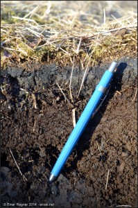
 I was actually just working in the field last weekend to prepare for a small summerhouse building for my parents but came through the ash layer from Eyjafjallajökull eruption 2010. Now four years later there already is a thin soil layer above the ash layer. I measured the ash layer and it seemed to have thickness from 2 cm to 3 cm in this area that is approximately 27 km from the summit of Eyjafjallajökull in SE direction (127° from North).
Long time update needed. The page used to have two versions, Icelandic and English version. Now I will continue more or less only in English. This page will then be divided into several sections not all available at the moment but will hopefully be in the future:
Loksins búinn að klambra saman ritgerðinni, skila og flytja fyrirlestur.
Herlegheitin eru hér.
Alveg teigt sig í það ítrasta. Viðmiðið var 6 bls. og línubil ekki 2 heldur 1,5. Svindlaði línubilinu niður í 1,25 og svo eitthvað ekki jafn stór spássía og flestir voru með. En ritgerðin mín leit þá frekar út eins og grein í tímariti því þar tíðkast ekki 12 pkt letur eða stórt bil á milli dálka. Endaði víst í tvöföldum orðafjölda annarra sýnist mér. Ég fæ vonandi frekar gott fyrir en vont.
Fyrirlesturinn er hér. Hann átti að verða 5 mínútur en Esther sá held ég aumur á mér og hann fór upp í eitthvað rúmar 6 mínútur án þess að mér væri vikið af velli.
Well, finally finish the work on my essay about geological history of Greenland and I also made the presentation. The essay is unfortunately only available in Icelandic: here. The presentation: here.